|
|
|
|
|
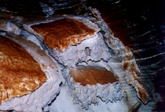
The Underground Lake is a moderately sized, active gypsum cave formed by partial collapse of a major dissolution cell. The main chamber is approximately half flooded with water and contains an active overflow stream in a small side passage. The cave is found in a line of sinkholes at the base of a 30 meter cliff. The cave is entered by going down a 45 degree scree field. The scree is composed of large smooth pieces of gypsum covered with a thin layer of mud. It is extremely slippery and requires a rope for protection from a slip. Once the cave is entered the scree is not as steep and composed of pea size fairly dry rock. The scree continues down until you are faced with an underground lake 55 meters long and 15 meters wide. Max Moseley in his article "The Gypsum Karsts and Caves of the Maritime", in Cave and Karst Science Vol 23 No 1 calls this a classical example of a dissolution cell. This gypsum dissolution cell is a large isolated underground chamber that has been modified by breakdown, forming a gently concaved chamber. While not unique the cells are generally smaller, formed by inlet/outlet passages and only become accessible when breakdown reaches the surface. Part of the cell is still intact where the water almost reaches the flat etched ceiling. The evidence of the cell formation is the small air space above the water's surface in this flat area. While the inlet streams are underwater the outlet stream can be followed for a short distance in a side passage. The combination of steady influx of water, high humidity slowing evaporation and the slow outflow of water keeps the cave water level almost constant year round allowing some unique formation just under the surface of the water. One of the things that makes these features special is the dissolution of the breakdown in the water. The cave is formed in one of New Brunswick's most important Mississippian gypsum deposits. Dating back to the 1800's the district has been the center of an active gypsum industry, but the recent economic down turn of the gypsum industry in this part of New Brunswick has resulted in the 1980 abandonment of the areas' quarries. The gypsum that is exposed is a gray to white rock formed in a shallow sea 300 million years ago. Under arid or desert-like conditions the sea water began to evaporate. As the process of evaporation continued the water volume decreased and the salt content increased until the water was no longer able to carry the mineral load. The minerals soon began to settle out on the sea floor, with the limestone carbonates settling out first due to their lower solubility. The gypsum sulfates then settled out which was in turn covered by a layer of sandstone from a later major flooding. The cave itself is found in a series of extremely large sinkholes across the middle of a synclinal basin that is surrounded by limestone. The history of Underground Lake appears to be longer than any other New Brunswick cave. The cave shows' the history of use by the walls that are disfigured with etched names and spray-painted graffiti. I have never liked graffiti even the historical graffiti that is found in some of the larger southern US National Park caves. But one interesting aspect of the graffiti in Underground Lake is the writing variation and style of the graffiti based on the age of the writing. The oldest writing was done with a flared style while the newer is characterized by bright colors and big spray painted print. The extensive network of old woods' roads hints of past logging or perhaps a past cottage mining operation. The cave is first mentioned by L.W. Bailey in the New Brunswick Natural History Society Bulletin #22 in 1904, in at represented the maritime in the 1971 Speleodigest with an article by Richard Breisch of California and than again in 1974 by K. Proctor in the Nova Scotia Speleological Society Newsletter #3. In 1980 gypsum mining in the area stopped due to the collapse of the market Albert County then tried to make better use of the area by promoting the cave for tourism. In 1981 an article appeared in the New Brunswick Magazine #6 written by M. Burzynski that put the cave on the tourist maps of not only Albert County but the rest of New Brunswick as well. The Underground Lake is now well known both locally and in the rest of New Brunswick. Protection for the cave was first suggested in 1983 by D.F. McAlpine of the New Brunswick Museum. In his publication the "Status and Conservation of Solution Caves in New Brunswick" he made two recommendations, first that the area become a Provincial Ecological Reserve to protect the bat hibernaclum and second that the cave be removed from the Albert County tourist literature to further protect the location. The first rough map of the cave appears in the Nittany Grotto newsletter which was reprinted in the 1971 Speleodigest, this map suggests another room where water was coming from three cracks in the wall. The 1986 Canadian Caver (Vol. 18 # 2) article by K. Sawatsky called the "Underground Lake, New Brunswick includes more detail because of first recorded dive of the cave. Another rough map done in 1988, with a great deal of differences in passages, appears in a New Brunswick Natural Resources Open File (OF 97-7) titled "The Caves of Southeastern New Brunswick" by S.P. Arseneult, J. Schroeder, D. Berube and R. Albert. We first mapped the lake in 1997 using a depth probe to determine the depth and verify that water was coming in the cracks. The cave appears to have a very steady level and flow. Baymount Outdoor Adventures is currently using the cave for guided spelunking tours along with several other area caves. With mining no longer a threat even though it is once again being discussed and the location of the cave slowly fading from the publics eye the future appears to be good for the Underground Lake. |
