


There are a few bits of information to keep in mind when trying to interpret
the tables in these pages.
Abbreviations
Newsletters and Magazines
IU
Island Underground
VN
VICEG News
JSM
Journal of Subterranean Metaphysics
CC
Canadian Caver
CC-CEC
Canadian Caver Special Issue - Cave Exploration in Canada (1976)
BCC
BC Caver
Books
UGM
Under Grotto Mountain. Chas Yonge 2001
CCR
Caves of the Canadian Rockies and Columbia Mountains. Rollins 2004
Survey Information
It’s important to remember that many of the longer cave surveys are works in progress, and the
current length and/or depth will change in time. The lengths or depths for caves in progress are
reported from a person holding the survey data.
Survey Accuracy
Cave surveying is conducted using some device to measure distances between survey stations,
some way to measure direction (either relative or absolute), and, ideally, some way to measure
difference in elevation. How this is done covers a spectrum of accuracy, from crude and quick to
laborious and (hopefully) accurate.
Most cave surveys in Canada use a fibreglass tape measured to the nearest centimetre,
a Suunto sighting compass for bearings, and a Suunto clinometer for angles between stations.
Usually, the passage dimensions are estimated and a sketch created in a notebook onsite.
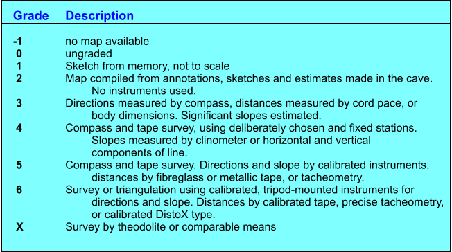
Here’s a general grading system for cave surveys, from the International Union of Speleology
Have a look at the source link for more information.
Lengths and Depths?
Cave depths are the vertical distance between the very highest part of a cave system to
the very lowest point. Often the highest point will be the edge of the entrance sinkhole,
though, this varies considerably depending on the “keenness” of the survey crew. Even the
lowest point can change somewhat, since if it is a sump (point that is waterfilled) this could
vary with season or be completely bypassed by cave divers.
Cave lengths very often depend on a both a combination of the actual extent of the cave
and the enthusiasm of the mappers. Surveyors mapping for the main passages and just
sketching minor side-passages will end up with a published cave length far less than the
meticulous crew who drag a tape into every nook and cranny.